

Computerised Spectrum Management
CONTENTS
Basic Requirements
*example of an integrated spectrum management system
*work procedure
*Application data
*Perform "sanity check", calculate link performance
*Search the national station database (and other databases)
*Perform frequency assignment
*Perform interference check
*Perform Collocation Interference check
*Perform checks for potential international interference
*Coordinate with neighbours
*Issue licence
*Perform notification to the ITU
*Conclusions
*Introduction to Using WRAP
*Starting WRAP
*Help Function and Documentation
*Opening a Project
*Exercise 1: Planning a Microwave Link Network
*Input Data
*Entry of Stations
*Calculate Link Performance
*Interference Analysis
*Interference within the network
*Interference from other stations
*Checking for Collocation Interference
*Frequency Assignment
*Exercise 2: Earth Station Coordination
*exercise 3: licensing
*Exercise 4: Coordination and notification
*
Computerised Spectrum Management
Olov Carlsson
Head, Spectrum Management
AerotechTelub
SE-351 80 Vaxjo
Sweden
olov.carlsson@aerotechtelub.se
Tel +46-470-42149
Fax +46-470-42042
Spectrum Management is a very complex process, involving many steps and considerations that need to be observed to allow interference-free services and an efficient utilisation of the radio spectrum. This process can no longer be handled by manual means with the large number of users of the spectrum and the high economical and political value of radio frequencies. Efficient computer support is needed. Some functions that should be part of computerised spectrum management systems are described in this presentation, with AerotechTelub’s commercial system WRAP serving as the example. The text is aimed at systems for spectrum management at a national level, which are typically characterised by multi-service capabilities including support for international coordination.
To fully support the spectrum management process there is a need for an integrated system, where multiple users can access information, perform technical analyses, perform administrative processes, share work, pass on work tasks and store results and documents. The basic requirement arising out of this is that there is a common database of information on radio stations that can be accessed by all users. The normal configuration would be to have a central database on a server, which can also conveniently be used for storing results from calculations, documents etc. that form part of the spectrum management process. Access rights for changing data in the database should be controlled, while there should be read-only access for all users. Data integrity should be maintained by scheduled automatic back-ups and preferably non-interruptible power supply.
The ability to handle various station databases is extremely important. These can be available from the ITU, such as the International Frequency List (now superseded by the ITU BR IFIC - International Frequency Information Circular). National station data held by the licensing authority should ideally comprise all radio emitters in a country, however military frequency utilisation is often based on specific allocations, where the civil authorities do not have information on the detailed frequency assignments and allotments. In any case there is an advantage if the spectrum management system can handle all these three sources of spectrum data: International, national civil and national military data.
The various station databases may be for read-only or read/write, depending on their application and the role of a particular user. The BR IFIC is obviously read-only, the civil national station database read-only if used by a military spectrum management agency and parts of the data in the national station database may be read-only for different categories of personnel or for particular applications.
Much of the work with radiocommunication systems is geographically related, where it is most convenient to have presentations of stations on a map background on screens and printouts. Accurate calculations of field strengths and signal levels require methods for propagation calculations that account for detailed terrain features, that can be stored in terrain databases. The typical set of geographical databases needed for these purposes are
Geographical databases often are a cost-driving factor for a spectrum management system, and reduced functionality modes should be available, for instance by implementing propagation models that do not require detailed terrain information.
The IDWM (ITU Digitized World Map) provides coastal contours and national borders. This data is useful for presentation of large areas, to provide some geographical orientation for the user. Another important information capability of the IDWM is when implementing certain calculation models to utilise the land/sea information and rain climate zones available in the IDWM. The propagation model ITU-R P.370 and the ITU Radio Regulations Appendix S7 (Earth station coordination contours) can make use of the IDWM.
An integrated spectrum management system should support the following types of work:
example of an integrated
spectrum management system
WRAP - AerotechTelub’s system for spectrum management - is fully integrated as described before. Within a single main screen interface it provides the following functions.
The Map Viewer constitutes the main Presentation Tool and performs all presentations using geographical data, either as a profile viewer, a common 2-D map or as a full 3-D map. The Map Viewer works with any combination of geographical data, results and scanned map images.
The Calculation Tools are capable of performing a large number of different tasks, supporting different radio services:
Many of the calculations involve the prediction of radio wave propagation, and there are several selectable models available to fit the desired applications.
Models based on detailed terrain information:
Models based on coarse terrain and land cover information:
Statistical models:
In addition to all these models the attenuation due to atmospheric gases can be added in accordance with the ITU Rec. P.676 Attenuation of atmospheric gases. Rain attenuation and hydro-meteor scatter are also handled. For earth-to-space paths the ITU Radio Regulations Appendix S8 "Method of calculation for determining if coordination is required between geostationary-satellite networks sharing the same frequency bands" is implemented, extended with the ability to select a more accurate propagation model as defined in ITU-R Recommendation P.619-1, items "Basic transmission loss", "Tropospheric scintillation" (from ITU-R Rec. P.618-6), "Ray bending" and "Precipitation scatter" (from ITU-R Rec. P.452-9.
The Administrative Tools consist of two different parts, both operating on the same station database as the technical system:
An example will be used to illustrate the benefits with an integrated system, based on a licence application for a microwave radio link network. This is based on an anticipated work-flow starting with a licence application and ending with issuing the licence, and if required, the notification to the ITU BR of the new stations.
The applicant should have listed basic facts about the stations for which a licence is sought. This typically includes geographical locations, antenna height above ground, transmitter power, antenna gains, required received signal level, required signal-to-interference ratio etc. The applicant may already have a preferred frequency band of operation and even suggestions of frequency assignment. Each licensing authority may have different requirements for the submission of data in the application, some requiring also a specification of which equipment that will be used to check for compliance with type approval standards. For this example it is sufficient with the parameters that constitute important data for the analysis of link performance and interference.
Make project for calculations etc.
Data for the stations are entered into the spectrum management system in a temporary workspace. The purpose for this is to have all relevant data under control to support the subsequent stages in the process. But this is still an on-going process, so the data should not yet be stored in the national station database.
Perform "sanity check", calculate link performance
The applicant should have performed basic link budget calculations and designed the links for the appropriate quality and availability. The licensing authority should nevertheless check the link performance for suitable design, for instance to make sure that the radiated power is reasonable so as not to create larger interference regions than necessary.
Search the national station database
(and other databases)
To provide basis for the continued process for frequency assignment and interference analysis there is a need to examine the frequency utilisation in the geographical area and frequency band of interest. This is done by searching the available station databases with geographically limited and frequency-limited criteria. Stations that are found, which are suspected to be subjected to interference from the new stations, or that may interfere with the new stations should be entered into the calculation project for further analysis. This is done automatically (if selected) in WRAP.
The frequency assignment function is used to assign frequencies to the new stations. Account is taken automatically to the interference from the new stations to the existing stations and the interference from the existing stations to the new stations. The frequency raster should naturally be compliant with the frequency plan for the band of operation. An appropriate propagation model should be selected to provide protection for the desired percentage of time.
The automatic assignment process accounts properly for the interference contributions from new and existing stations, but there may be an interest to analyse and quantify the resulting interference margins by a specific interference check. In this process it is easy to find the most contributing interferer and to judge whether its contribution is acceptable.
Perform Collocation Interference check
The specific locations for the new stations would normally have been selected by the applicant to be suitable from a linking point of view. The applicant may or may not have the capabilities to judge whether the local interference situation at the intended site for installation may pose a problem. The licensing authority probably has a better knowledge about at least the already licensed stations at the sites, and should have the capability to examine the frequency assignment for local interference such as intermodulation, harmonics, transmitter spectrum mask and receiver selectivity. For really detailed and accurate collocation interference analysis there is a need for quite detailed performance data of receivers and transmitters, as well as very detailed information on the exact locations of antennas at the site. This level of detail normally goes beyond the responsibility of the licensing authority, but it may anyway perform some calculations and provide guidance to the applicant or express concern that more detailed investigations should be performed.

Perform checks for potential international interference
The BR International Frequency Information Circular should be consulted for potential interference to or from stations in countries within a typical coordination distance. Bi-lateral or multi-lateral coordination agreements may already have been established incorporating coordination zones, in which case the search can be limited to within the zone along the border. Otherwise interference calculations should be performed, with station characteristics determined from the BR IFIC and complemented with appropriate additional data if needed.
Earth stations in frequency bands shared with the terrestrial services can be found in the BR IFIC/Space Radiocommunications Stations database. Data for these stations can be extracted and entered as characteristic earth station data for generation of the coordination contours using the Earth Station Coordination tool. Terrestrial stations falling within the coordination contour, with over-lapping frequency bands, should be examined further for interference potential by using the Interference tool.

The investigations of potential interference or location of the new stations within pre-determined coordination areas as agreed with neighbouring countries may necessitate coordination with authorities of neighbouring countries. This should be performed in accordance with coordination agreements (if they exist). The generation of the appropriate ITU T-series notification form can be done to support the coordination.
Pending the outcome of the coordination (if needed), a temporary licence may be issued. In many cases it will be obvious for the licensing authority whether the coordination process will have a positive outcome, so that the licence can be issued before the coordination is completed.
Perform notification to the ITU
The appropriate notification form can be completed and sent to the ITU BR (if needed). In this example it would be the T11 form. The system provides tracking of the notification process and allows for the suppression and modification of the notifications.
Great advantages can be gained by implementing an integrated, computerised spectrum management system through the convenient and rational handling of the complete process, including technical analysis, licensing and coordination. The foundation for such a system is a common station database, that holds all relevant data and that is accessible for all personnel working with various parts of the spectrum management process.
The system should incorporate suitable functions to allow technical analysis of the wide variety of radiocommunication systems that are the responsibility of the spectrum management authority. This calls for the implementation of a number of radio wave propagation models as well as analysis methods that have a general applicability. In some cases service-specific methods need to be utilised due to international agreements and recommendations, or for systems that have unique features that need to be accounted for in detail.
Welcome to WRAP!
WRAP provides all necessary computation and analysis support for frequency management and planning for a number of different radio services. Calculations are carried out with the aid of frequency and equipment databases or by manually entered station data. The results are presented geographically, facilitating planning and decision making. Administrative tasks such as licensing and coordination/notification are performed in the WRAP Licence Manager.
WRAP makes it easy to perform advanced tasks in one dedicated piece of software. The user interface has been carefully designed, taking full advantage of the features provided by the Win32 environment. The result is a user interface that is very powerful, yet intuitive and easy to understand. Therefore, operating WRAP requires only a minimum of computer skills.
Since there are so many possibilities when working with WRAP there are some exercises to make it easier to exploit the software. These exercises will give a guidance of how to work with WRAP. The exercises are fully described in the User’s Manual, Part 1.
The WRAP standard installation creates entries in Windows Start menu – Programs. Perform the following to start WRAP:
The following main window appears (note that the database and project folders have been expanded by clicking once on the + sign in front of some of the folders and trhat the search query Query Qstation has been executed).

The main window is divided into four major parts:
At the top there is a text-based menu bar and just below you can see a icons for various tools and functions. Only those icons that are applicable to the particular view and selection of stations are highlighted and therefore available. The others are dimmed.
Help Function and Documentation
WRAP includes a Help Function, including a description of every window in the system. This is activated by pressing F1. The Help function opens automatically at the part that describes the window that was active when pressing F1.
The complete documentation for WRAP is normally available (if copied to the hard-disk) in the folder …\WRAP\UsersGuide according to the following folder view:
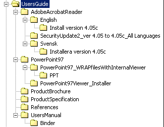
Documents are provided in Adobe Acrobat 4.0 format. The Acrobat reader is available in the folder for installation if this program is not already installed on the computer.
The …\UsersManual\Binder folder contains the complete User’s Manual.
The …\PowerPoint97\… folder contains Microsoft PowerPoint presentations of WRAP, both an overview and specific presentations of each major tool. They can be shown without a PowerPoint installation on the computer.
A good way of quickly getting started with WRAP is to open some of the project files that are available in the …\WRAP\Samples folder. A project file includes information on stations, equipment and map settings that were used when saving the project file. Many results that were calculated can also be saved in the project file.
Perform the following to open a saved WRAP project:
Exercise 1: Planning a Microwave Link Network
The objective in this exercise is to plan and design a small 16 Mbit/s microwave link network in the 4 GHz band. Standard stations and equipment data available in the demo version of WRAP’s station database should be used. Assume the following:
The Samples folder contains a project file that sets the map view to suit this exercise. Perform the following after starting WRAP as described on page *:
The map now displays the names of the towns to be linked. The centre position of the map can be adjusted by right-clicking at the desired new centre position and selecting Centre position in the menu.
Note: An earth radius factor of 0.6 is commonly used when planning radio links for high time availability.
The end points of the link have now been set. The next step is to create stations at these points. This is performed as follows:
A feature that allows automatic entry of existing station coordinates to a new station should be used for the continued definition of the link network. This is done by right-clicking on an existing station in the upper right list view and selecting Set As Tx. Then the cursor is placed at the appropriate location in the map for the selection of Rx Position. This is a convenient way of building a chain of link hops.
Continue as follows:
Hint: The map display can be changed in many respects. One way to allow quick identification of high spots is to right-click in the map and select Properties – Raster Data – Type – Terrain heights, Floating colours. This sets the map to display a grey-scale with the lighter shades being higher in elevation. Also make sure that the Info boxes are checked to display height and terrain codes in the status bar at the bottom of the main window. The z-value gives the height above sea level.
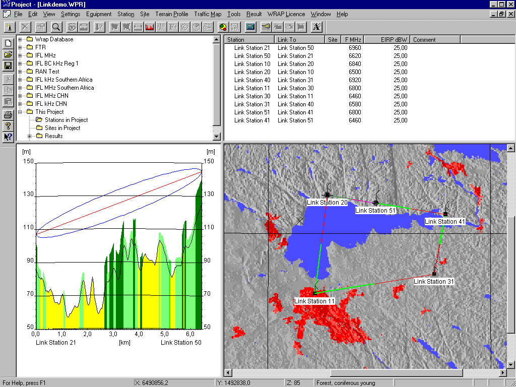
It is common practice to make sure that each link point transmits in the same frequency band. Otherwise interference may become severe from a transmitter operating in the same band as a receiver. So ensure that frequencies are reversed. This can be checked by showing the links on the map. Correct frequency distribution is indicated when each node shows the same colour (green or red) in each of its two directions.
Continue in this manner until only the final link between Finspång and Motala remains. Perform the following:
Now the complete network can be shown on the map and each link can be analysed for the proper clearance above the terrain. Perform the following to do this:
This procedure should work fine for all links except for the one between Finspång and Motala. A much higher antenna height would be required here. Even with 60 metre high antennas at both ends you will probably not achieve full clearance.
Here a relay site is required. A convenient way of finding a suitable location is by using an area-coverage calculation called Minimum Required Antenna Height. This will show the areas that have coverage to both Motala and Finspång with a certain antenna height above ground at the relay site. Perform the following:
The calculation may take up to a few minutes if you are using a slow computer. The progress of the calculation can be seen in the upper left view. Perform the following to see this and set the subsequent map presentation:
Now two link hops need to be created to divide the original Motala – Finspång link. This can be performed conveniently by first using the Duplicate function to create a complete copy of the original link. Then the respective end points can be moved to thye new site defined by the Tx Position. The station names should obviously be changed to reflect the new locations., and the frequencies need to be checked for the proper frequency arrangement at each location.
Perform the following:
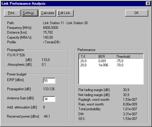
Now all links should have a reasonable free line-of-sight. The next step is to calculate the link performance. Do as follows:
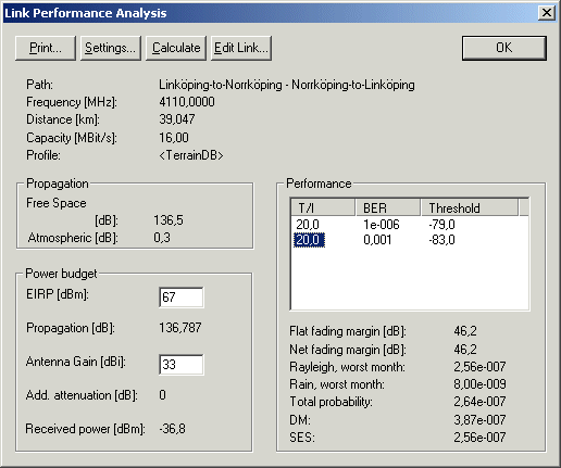
Note that the line for T/I 20.0 – BER 0.001 – Threshold –83.0 has been marked. This is necessary to show the result for DM – Degraded Minutes and SES – Severely Errored Seconds. The SES value constitutes the most important result, and in this case probability of unavailability due to too high bit error rate is only 2.56x10⁻⁷, to be compared with the design objective of 1.5x10⁻⁴. This means that the link budget can be reduced by for instance selecting antennas with lower gain or reducing the transmitter power. In this particular case it seems to be sufficient with about 40 dBm EIRP (Effective Isotropically Radiated Power). All links can be checked for availability.
Under Settings… you can find selections of various methods, propagation models and atmospheric conditions and you may experiment with other settings.
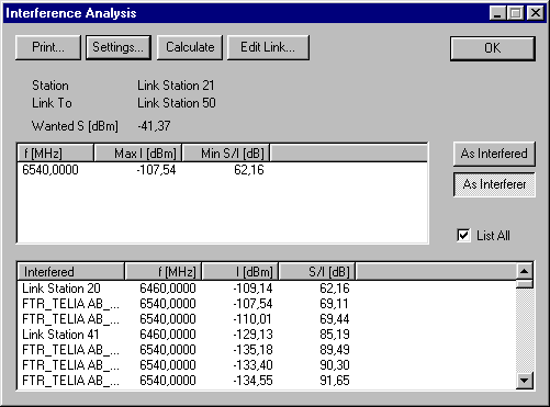
Interference within the network
The new network should be checked for potential interference within the network and against other use of the assigned frequencies. First you may check within the network by using the Interference tool. Perform the following:

Note that the frequency entry in the top list view has been marked to display the individual interference contributions as listed in the lower box. The total interference as received by the Motala-to-Mjolby station is –65 dBm and the signal-to-interference ratio is 34 dB. These values are quite acceptable. Selecting the As Interferer function will show the interference that the transmitter of Motala-to-Mjolby causes in the other receivers in the network.
You may continue and check the remaining stations for interference.
Interference from other stations
Interference to and from other users of the assigned frequencies should be checked. This requires knowledge of the overall frequency utilisation, such as a national master station database. WRAP supports this, but the demonstration version is limited in functionality. To demonstrate some of this it is possible to search the IFL (ITU’s International Frequency List, to be replaced with the BR IFIC – International Frequency Information Circular). This requires that the IFL in WRAP format is installed, which will show up as an additional station database named IFL in the upper left database folder view.
In this particular case it is of little interest, since Sweden does not have any entries in the IFL for this frequency. Norway, Denmark and Germany have entries at both 3897 MHz and 4110 MHz, but the distance is so large that there is no potential of interference.
Anyway, the procedure is to perform a geographically limited search on the frequencies of interest. Any matching station entries in the database can then be added to the WRAP project and the interference contribution can be calculated.
Checking for Collocation Interference
There may be a risk for interference if the new stations are located near existing radio installations. This may give rise to interference such as intermodulation, harmonics etc. Analysis of this can be performed with the ![]() Collocation Interference tool. The normal procedure would be to search for other stations in the vicinity of each of the new installations and add these to the project.
Collocation Interference tool. The normal procedure would be to search for other stations in the vicinity of each of the new installations and add these to the project.
Run the Collocation Interference tool just to illustrate the procedure. Perform the following:
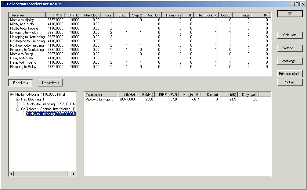
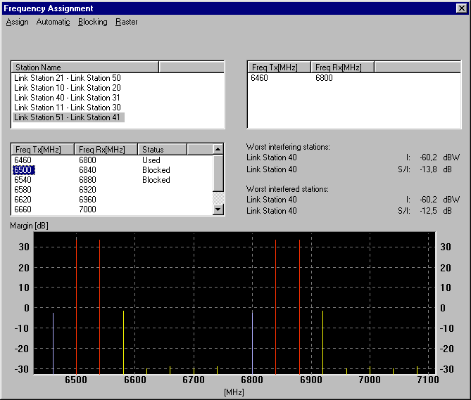
The interference check showed that every link in the network operates satisfactorily with the first attempt to assign frequencies. This was such a simple case, requiring little or no support in the selection of frequencies. An automated method of frequency assignment should be used when it is difficult to find suitable frequencies. This is done with the ![]() Frequency Assignment tool.
Frequency Assignment tool.
You can try this out in the following way:
Finally: Save the link stations to the station database. This is done by marking all stations, right-clicking and selecting Save.
Exercise 2: Earth Station Coordination
Many frequency bands in the microwave range are shared between fixed services and various satellite and space services. The ITU prescribes that a specific coordination procedure shall be performed to secure the compatibility between space and fixed services. The procedure is illustrated in the following.
The ITU publishes the Space Radiocommunication Stations on CD-ROM and regular updates through one of the BR IFIC CD-ROMs. There is associated software to search for earth stations and satellites to allow analysis of interference and to initiate, if needed, a coordination procedure.
A search was made to find a receiving earth station with which there may be a need to coordinate since its frequency use is overlapping with the 3897 MHz frequency of the link network that we just planned. The earth station NIT 5 is located in Norway, receiving the satellite Intelsat 5 Indo C1 at 63 degrees east in the geostationary orbit.
After establishing that a frequency overlap exists the particular data for this earth station was entered in WRAP and stored in a project. The satellite was created and stored under the name Intelsat 5 Indo C1. Now perform the following to calculate the coordination area around earth station NIT 5:
This project uses another geographical database, the GTOPO30. This is a world-wide database having height information in a raster with 30 seconds resolution (about 900 metres in north-south direction, 900 m or less in east-west direction) and a terrain classification of "land" and "sea". The link network that was created in the previous exercise has been included in this project.
Show all the stations on the map and notice that all the links are within the contour, thus requiring the coordination procedure to be performed. The next step is to calculate the interference contribution in the earth station from the link transmitters that operate within the frequency band of the earth station. This is done with the Interference tool.
Perform the following:
The resulting interference level is very low, far below the sensitivity of the earth station. This should mean that the links would pass the coordination procedure with Norway without problems.
Licences are handled in a separate application, the WRAP Licence Manager. This application operates on the same station database as the technical system, meaning that it can retrieve required technical data from the database and add various administrative data associated with the station(s) to be licensed.
Perform the following to start the Licence Manager:
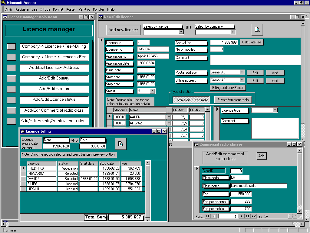
Having entered complete data into the form gives (for example) the following view:

There are several functions available for editing basic data that then can be selected from drop-down lists. These are available in the first window – the Main Menu.
Data generated in the licensing process are stored in the station database and can be retrieved later.
Exercise 4: Coordination and notification
This exercise deals with the coordination and notification process that is necessary in many instances. The rules for when coordination and notification are required can be found in the ITU Radio Regulations.
A result of the first exercise was that the coordination contour (receiving) around the Norwegian earth station NIT 5 extended to include all the radio link stations that were planned in the exercise. Some of them transmit on an overlapping frequency assignment. This means that coordination should be performed with the Norwegian telecommunications administration. After successful coordination a notification on the coordinated link stations should be sent to the ITU BR (Bureau of Radiocommunications) for entry in the master international frequency register.
The handling of the notification process is supported by the WRAP Licence Manager. Perform the following to illustrate how this is done.
Detailed information on the fields in the notification forms can be found in Ref 27 in the WRAP References document in the UsersGuide\References folder.
The Coordination form now should display a line for the just completed T11 notification. Marking this line and clicking on Show will display the stored form for viewing and printing.
A change to a notification that has been submitted as and Addition (i. e. for a new entry to the ITU BR) is notified by using the MOD (Modification) function.
Deletion of an existing entry in the master international frequency register is performed by the SUP (Suppress) function.
Withdrawal of a notification (ADD or SUP) is done with the WITHDRAW function.
The history of submissions for a particular station can be viewed by selecting a station of interest from the drop-down list that is seen when selecting that station in the list Previously coordinated stations.
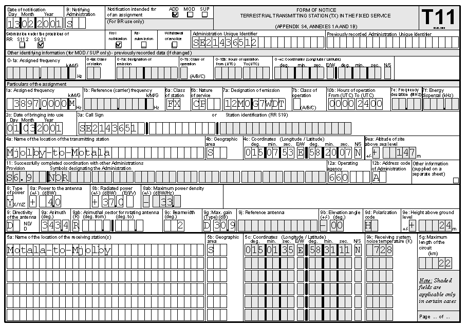 The just completed T11 notification may look as follows when viewed with the SHOW function: